
Aug. 28, 2026: Wildfire Smoke Air Quality Update
Posted on August 28, 2026

The current air quality across Missoula County is Good to Moderate. See current air quality conditions at Fire.AirNow.Gov.
This weekend has cooler temperatures and scattered rains in store for us as a cold front moves across Montana. As you can guess, an increase in humidity and moisture moderates fire behavior but storms accompanied with lightning may cause new fires. And, rain is not necessarily widespread across all regions that have active fires. Through Saturday, southwesterly transport winds will continue to pull smoke from fires in Oregon and Idaho towards Missoula County. Come Sunday, westerly transports winds may carry smoke from Washington and northern Idaho west. For weekend plans, areas in closer proximity to active fires or downwind of them will see the greatest smoke impacts especially overnight. There are several large fires burning across Montana currently that may impact your recreation plans.
You can find more info on fires across Montana at MTFireInfo.org.
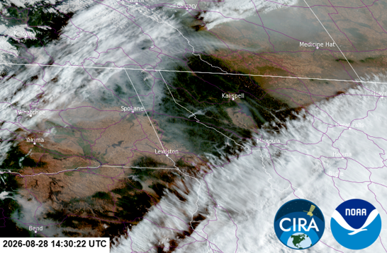
GOES West satellite imagery from 8:30 a.m. on Friday, Aug. 28, 2026
Regional fires and several local fires in Idaho have the highest chance of degrading our air quality in Missoula County, although high concentrations of smoke are not expected for the weekend. The Moose Mountain Fire northwest of Lolo Pass continues to grow on the west side and the east/northeast sides of the fire. The fire has burned almost 5,000 acres.
Last night, smoke settled in and you could smell it, but still the monitors were reading at the high end of Moderate with a couple reading Unhealthy for Sensitive Groups for a short time. This is a great example of increasing concentration of smoke or PM2.5 in the air as mixing heights decrease. We’ve seen this diurnal trend all smoke season with some nights being more obvious than others. To visualize this, look at the graph of mixing heights below.
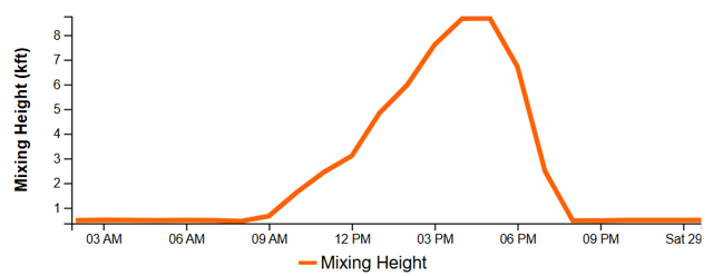
Forecast of mixing heights for Missoula on Friday, Aug. 28, 2026
The National Weather Service defines mixing height as “the height to which a parcel of air, or a column of smoke, will rise, mix or disperse. A column of smoke will remain trapped below this height.” As the mixing height increases in the morning, the amount of space or the volume increases. This leads to the dispersal of any smoke that was trapped overnight at surface level and therefore improves air quality as PM2.5 becomes less concentrated. In the image above, you’ll notice that the mixing height for today doesn’t rise until 9 a.m. and is slow to rise. On days like that, it may take a little longer for the smoke to disperse and air quality to improve especially if the concentration of smoke is high.
PM2.5 is measured in microns per meter cubed, so it’s measuring the amount of particles in a cubic meter or a volume of space. As the mixing heights lower in the evening, any smoke overhead becomes more concentrated as the volume of mixing space decreases. Once the mixing height increases, transport winds start their work. They are a bit of a double-edged sword being that transport winds both disperse smoke but can also carry smoke from Oregon, Washington, or hundreds of miles away.
The clearer skies have been much appreciated lately, but don’t forget to continue to be ready for wildfire smoke if it gets worse again. Think back to a couple of weeks ago – was there something you wish you had when the air quality was Unhealthy? Maybe it was an N95 mask that fits your face well, a replacement filter for your HEPA air cleaner, a MERV 13 filter for your DIY box fan filter, or just a ton of answers to your questions about the health impacts of smoke.
Mushu, your local air quality kitty, wants you to be wildfire smoke ready to stay healthy throughout the year! Learn more and educate yourself at MontanaWildfireSmoke.org!