
Aug. 3, 2026: Wildfire Smoke Air Quality Update
Posted on August 03, 2026

The current air quality across Missoula County is Unhealthy for everyone. Some areas are experiencing Very Unhealthy. See current air quality conditions at Fire.AirNow.Gov.
Throughout yesterday, wildfire smoke from fires in Washington was transported west towards northwestern Montana. As the smoke settled into the Flathead Valley, smoke moved south down towards the valleys in Missoula County. Air quality began to worsen after 8pm in the northern parts of Missoula County and worked its way south. It’s settled into Missoula Valley and is slowly making its way to Lolo (Lolo and Petty Creek have Unhealthy for Sensitive Groups air quality; Lolo Pass has Good air quality). Smoke from the Cascade Fire in the Nez Perce-Clearwater National Forest and the North Fork Fire west of Darby have settled into the Bitterroot Valley causing air quality that is Moderate to Unhealthy for Sensitive Groups.
Check out regional fire information at Inciweb.wildfire.gov.
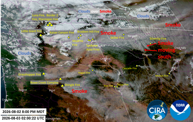
GOES West satellite imagery
As an upper-level ridge of high pressure builds over the west, smoke will disperse through the region including over Missoula County. Northwesterly transport winds will bring wildfire smoke from Washington further south than this weekend into Missoula County. The main fires sending smoke towards western Montana are the Kaiser Canyon Fire over 136,000 acres, Modrite Fire almost 50,000 acres, the Bradeen Hill Fire at 4,300 acres, the Spokane Area Fires at 7,708 acres, and the Little Giant Fire over 38,000 acres.
Our thoughts go out to the community of Spokane while many are evacuated and homes are lost. The smoke from the Spokane Area Fires will have a more complex mixture of harmful pollutants since it’s burning through man-made materials.
Learn more about the health risks or wildfire smoke at MontanaWildfireSmoke.org.
Yesterday afternoon and evening were a much needed break from the smoke but depending on where you were for the weekend you may have experienced the heavy smoke from Washington I mentioned in the last few updates.
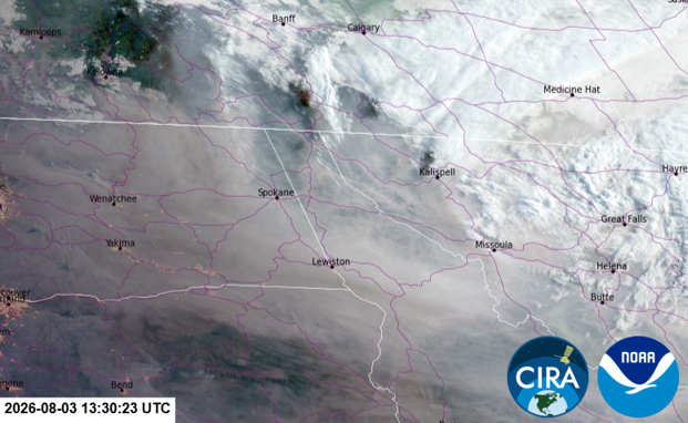
GOES West satellite imagery
North of Missoula County in the Flathead and Clark Fork Valleys, they’re also experiencing air quality that’s Unhealthy for Everyone to Very Unhealthy. Be sure to check in on your friends or family in town and around the state when you see wildfire smoke that is impacting their area. If they don’t already, encourage them to get a portable air cleaner with a HEPA filter or a MERV 13+ furnace filter attached to a box fan to clean their indoor air.
When the Air Quality Index is Red or Unhealthy for Everyone, everyone should shorten and reduce the intensity of any outdoor activities and take steps to limit your smoke exposure. Sensitive groups should avoid long or intense outdoor activities and limit time spent outdoors and move activities to a clean indoor air space. Everyone will likely experience symptoms of short-term exposure to wildfire smoke such as coughing, wheezing, shortness of breath, fatigue, respiratory irritation, and congestion. People with asthma should follow their asthma action plan and keep quick relief medicine handy. People with heart or lung disease should contact their health provider if experiencing symptoms associated with smoke exposure.
When the Air Quality Index is Purple or Very Unhealthy for Everyone, everyone should avoid long or intense outdoor activities and take steps to limit your smoke exposure. Sensitive groups should avoid all physical activity outdoors. Consider rescheduling or moving activities indoors to a clean air space. There is significant risk of increased respiratory effects. Everyone will likely experience symptoms of short-term exposure to wildfire smoke such as coughing, wheezing, shortness of breath, fatigue, respiratory irritation, and congestion. People with asthma should follow their asthma action plan and keep quick relief medicine handy. People with heart or lung disease should contact their health provider if experiencing symptoms associated with smoke exposure.
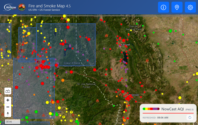
EPA Fire and Smoke Map as of 8 a.m., Monday, Aug. 3, 2026.